Ocean Business Ready for Business
Hands-on Update on Ocean Technology – Science and Business
The bi-annual event Ocean Business is coming to the NOC, Southampton from 4-6 April 2017. Three days of ocean technology engineering and science, knowledge sharing, hands-on training and demos as well as networking. The exhibition space is completely sold out, including more than 340 exhibitors. A selection of the businesses represented give a taster of their innovations in this preview. Better still, of course, is to come and see and experience for yourself!
Ocean Business is more than just a trade show. There will also be seminars, workshops by suppliers, a general conference as well as a conference organised by the NOC. A B2B Matchmaking event is scheduled for Wednesday 5 April. For the younger generation, the Ocean Careers Programme is another ‘not to be missed’ part of the exhibition. Side events are being organised by IMarEST & MLA, the Marine Alliance and Jerico Next. The Hydrographic Society UK will be organising its AGM during the days. For additional information and free registration, go to www.oceanbusiness.com.
Applanix
Applanix Corporation, a wholly-owned subsidiary of Trimble, designs, builds, delivers and supports products and solutions designed specifically for the hydrographic survey industry. Even in the harshest marine environments, our products and solutions provide robust, reliable and repeatable positioning and motion compensation solutions from moving boats and vessels. Marine-based mobile mapping and positioning with Applanix technology cuts costs associated with marine surveys and it also delivers tremendous accuracy.
www.applanix.com, K13
Applied Acoustics
Applied Acoustics will be introducing its latest USBL positioning system the Nexus Lite in Southampton alongside its big sister, Nexus 2, that was launched in London only last year. As with all systems designed by Applied Acoustics, the highly advanced positioning and tracking system is quick to deploy with easy set up procedures and can be used with a variety of Applied Acoustics’ positioning beacons, legacy products and transponders from third party manufacturers. It has bi-directional Sigma spread spectrum acoustics, 8 target tracking and a small surface console mounted within just a 1U enclosure for connection to a laptop or tablet PC.
Bibby Hydromap
Established 20 years ago, in 2017 Bibby HydroMap are celebrating their anniversary at Ocean Business and will be hosting a range of events, activities, and competitions to mark the occasion. Firstly, they will be introducing their new Teledyne Blueview BV5000 and describing their experience in using the system for port, harbour and inland waterway inspection, along with data examples. Secondly, BD Manager Michael King will be presenting on our advances in the field of ferrous and non-ferrous UXO surveying using a range of survey sensors and deployment techniques. Their 20th Anniversary drinks and nibbles reception event will be held on Wednesday 5 April, before the Gala Dinner, on their stand Q8. For further information on any of these events and registration information please email [email protected].
develogic
develogic developed a new ECB.PopUp System – an expendable communication buoy. These popup data ferries are ideal for transporting data from subsea installations to the customer’s data network without the need of installing a surface relay system or paying regular visits in order to download data. One launcher holds up to 6 units. The launchers are also daisy-chainable. The release of popups can be triggered based on a programmable schedule or by threshold violations in the logged data itself. As the ECBs are equipped with GPS and LED strobe light, they can also be easily recovered at the surface. The ECBs are available with 2,000m or 6,000m depth rating. develogic will show these and other systems at the Ocean Business 2017. During four training and demonstration sessions visitors will be able to have an insight on the ECB.PopUps as well as modular seafloor landers and a compact gateway buoy.
EdgeTech
EdgeTech designs, manufactures and sells industry-leading side-scan sonar, sub-bottom profilers, bathymetry systems and combined sonar systems. Additionally, the company produces world-class underwater actuated and transponding solutions including deep-sea acoustic releases, shallow-water and long life acoustic releases, transponders, reliable USBL acoustic tracking and positioning systems, and custom-engineered acoustic products. From 4-6 April 2017 at Ocean Business in Southampton, UK, EdgeTech will be showcasing the new 2300 mid-to-deep water combined sub-bottom profiler and side-scan sonar system (with optional bathymetry). The 2300 will be on display at the EdgeTech stand.
www.edgetech.com, B9.
Geo-matching.com
Geo-matching.com offers a complete overview of sonar and echosounders, positioning and navigation solutions, subsea and surface vessels, hydrographic software and more. With direct access to accurate and up-to-date technical specification lists, manuals, videos and case studies, Geo-matching.com should be your first port of call when gathering technical product information. The search filters make it easy for you to select products that fit your requirements. You can compare up to 4 products at a time and export the data in PDF format if you wish. This significantly reduces the time spent on preparing product surveys for your projects. Moreover, Geo-matching.com connects you with manufacturers and suppliers worldwide to further support your project needs.
Geosoft
Geosoft provides state of the art mapping and data visualisation software for the analysis and interpretation of subsurface geoscientific data. In the underwater environment, Geosoft Oasis montaj is widely used as a platform for handling large volumes of magnetic data in the geophysical survey and investigation phase of marine construction projects. Application of the software can help to detect and locate UXO, buried cables and pipelines, and offer clearer insight to new archaeological sites and ocean contamination. Geosoft will host a demonstration session to showcase the latest UXO Marine tools and workflows with some case studies presenting the wider uses of Oasis montaj. Geosoft is also hosting an introductory level Oasis montaj and UXO Marine training course in Southampton from 2-3 April. For full details on these events and how to register, please contact Lorraine Godwin, Global Business Director, at [email protected].
www.geosoft.com, G8
HELZEL’s WERA HF Ocean Radar
HELZEL Messtechnik’s ocean radar 'WERA' provides high-quality ocean current maps for ranges of > 200km offshore. WERA provides maps of significant wave height as well as directional wave spectra within 50% of the current mapping range. Why rely on single point measurements (buoys) when you can have access to area-wide data with the convenience of land-based instruments? The high-resolution current maps resolve even sub-mesoscale surface current structures. Diverse comparisons of surface currents measured by WERA with subsurface currents (ADCPs) as well as drifters show an excellent correlation. Combination of the real-time WERA data with numerical ocean models offer opportunities to improve the accuracy for oil spill drift prediction and search & rescue operations. This shore-based technique offers the best price performance ratio compared to other ocean sensing instruments.
www.helzel.com, W36
Hydroid
Located in the US and a subsidiary of Kongsberg Maritime, Hydroid is the world’s most trusted manufacturer of advanced Autonomous Underwater Vehicles (AUVs). Our Marine Robotics systems provide innovative and reliable full-picture solutions for the marine research, defence, hydrographic and offshore/energy markets. Our products represent the most advanced, diversified and field-proven family of AUVs and AUV support systems in the world.
www.hydroid.com, P1.
Hydro International
Hydro International started out as a print magazine in 1996 and soon developed into a the multimedia platform it is today, featuring a successful website and respected weekly e-newsletter. The magazine is international in scope and focuses on bringing to its readership topical overviews and the latest news and developments in the technology and management of hydrographic activities. Hydro International seeks and publishes the opinion of leading hydrographers on the state of the market, technical issues and national and international policies.
www.hydro-international.com, R4
Kongsberg Maritime
Kongsberg Maritime will showcase the innovative ‘Eelume’ swimming robot on its stand. With its slender and flexible body, the Eelume robot provides access to confined areas that are difficult to inspect with existing technology. Eelume robots will be permanently installed on the seabed and will perform planned and on-demand inspections and interventions. The solution can be installed on both existing and new fields where typical jobs include: visual inspection, cleaning, and adjusting valves and chokes. These jobs account for a large part of the total subsea inspection and intervention spend. Alongside the ground-breaking, disruptive Eelume technology, Kongsberg Maritime will also show a cross-section of its diverse subsea technology portfolio. De facto industry standard systems from the company’s camera, subsea transponder, sonar & echo sounder and AUV product lines will all be on show, making Kongsberg Maritime’s stand a must-see for visitors.
www.km.kongsberg.com, N1-P2
Leica Geosystems
Leica Geosystems airborne Lidar sensors for hydrographic survey collect combined data for bathymetry and topography. For nearshore surveys, the Leica Chiroptera II collects seamless data from water to land with up to 25 metres water penetration. When fitted with the Leica HawkEye III deep bathymetric module, the survey water penetration can be increased up to 50m with the highest possible efficiency. The airborne Lidar sensors are equipped with the Leica RCD30 high-resolution 80-MP camera, enabling RGBN colouring of Lidar point clouds, as well as production of ortho image mosaics in RGB or CIR. The turnkey Leica Lidar Survey Studio software allows simultaneous processing and quality assurance of all sensor data. Users can quickly create coverage plots, check accuracy, check point density, 3D visualise the data as well as review and extract Q/A reports.
Marinestar GNSS
Marinestar high performance positioning products and services delivered to you by Fugro Satellite Positioning are able to meet a varied range of applications in dredging & marine construction, wind farm installation, cable lay, naval and hydrographic/oceanographic surveys. Marinestar services deliver up to 8cm (vertical, sigma 2) accuracy in high availability using eight overlapping L-band satellite beams. With GPS, GLONASS, Beidou and Galileo constellations (at customer choice to combine) redundancies as well as precision gains are made available. Our most recent development is the fixing of ambiguities of the GPS constellation leading to the G2+ or G4+ L-band service. Our redundant infrastructure and 7x24 global customer service makes this precise positioning service the tool you need.
www.fugromarinestar.com, V13.
MMT
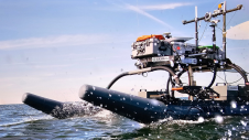
MMT is exhibiting at Ocean Business. You will have an opportunity to listen to their presentation at the Ocean Business 2017 training and demonstration programme on Wednesday 5 April at 12 noon on the topic: ‘Geophysical, geotechnical, environmental, UXO and advanced ROV surveying’. Pop by MMT’s stand and do not miss out on the wine trail that MMT are sponsoring. With their innovative and high-speed Surveyor Interceptor SROV on the market MMT have new information to release onsite in their stand. And important information to all visitors of MMT stand: Greet MMT by saying SROV ROCKS and receive a fun freebie.
www.mmt.se, K1
Nautikaris
Nautikaris will be presenting the latest developments of their product portfolio. They are specialised in hydrographic, oceanographic and meteorological systems and sensors, integrated subsea communication systems, inertial navigation and GNSS positioning products, wireless Small band radio telemetry networks, underwater connectors, rugged data collectors, Solar Marine Led navigation lights and professional lightweight inspection ROVs. Additionally, Nautikaris have acoustic real-time 3D Imaging systems for rental with experienced operators. Nautikaris has become a Videoray ROV certified service centre and holds their European distribution centre. Their customers count on them for their high-quality products combined with ease of use and a flexible and professional support team.
NORBIT
Experience multibeam survey proficiency as NORBIT Subsea demonstrates speedy high-resolution bathymetric multibeam surveying from any platform. At this event, we release firmware/software 10.2 - this includes a concise interface for single/dual head multibeam and GNSS-INS. Bridging the gap of parallel technologies, the WBMS family is the most compact, high-resolution, wide swath and cost-effective system to date.
norbit.com/subsea, V27
NovAtel
NovAtel’s high-precision GNSS receiver technology and correction services are trusted by marine integrators around the world. Our expansive OEM product line, which includes our SPAN deeply-coupled GNSS + Inertial Navigation System (INS) technology, delivers robust position, heading and attitude solutions for the most challenging hydrographic survey requirements. Our Oceanix Nearshore Correction Service utilises Precise Point Positioning (PPP) corrections, from our proprietary corrections network, to provide high-accuracy positioning, delivered via satellite 24/7, complementing nearshore network and local RTK networks. The flexibility of our world-leading GNSS receiver platform ensures easy integration into a wide variety of marine products and applications. Our team of highly skilled customer support personnel is on hand to provide full engineering support to our marine customers whenever assistance is required with the integration process.
OceanWise
Data is the most important resource of any organisation after the people it employs but is often taken for granted. As a result, this vital resource is often misunderstood, misused or worse still, just ignored! OceanWise specialises in all aspects of marine environmental data acquisition, data management, GIS and other services and can help you modernise your approach to data management. We provide tools and expertise, developed in conjunction with our customers, to better manage marine and coastal assets. By streamlining operational workflows associated with compliance and conservancy, asset management, chart production, tidal and weather monitoring and publishing, improved situational awareness and decision making will be gained. We will be showcasing the very latest developments in our Port-Log online real-time services and our Enterprise GIS productivity tools. So don’t let poor data management put your operations at risk; work with Marine Data experts…”where your data matters!”
www.oceanwise.eu, R5.
Ocean Server Technologies
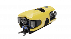
Ocean Server builds the first commercially developed family of low cost Autonomous Underwater Vehicles (AUVs), Iver, ideal for coastal applications such as sensor development, general survey work, subsurface security, research and environmental monitoring. These modern AUVs are single man-portable and feature simple point and click mission planning
QPS
QPS BV (Quality Positioning Services) makes industry leading software for collection, post-processing and visualisation of maritime geomatic data. Our products QPS QINSy, QPS Qimera and QPS Fledermaus seamlessly partner with third parties, to solve problems and gain efficiencies for maritime-related business. QPS QINSy is a software suite used for many types of maritime geomatic surveys, ranging from simple single beam surveys up to very complex offshore construction works. QPS Qimera is an evolution in hydrographic data-processing, and it combines the core technologies of QINSy and Fledermaus. QPS Fledermaus is a powerful tool used by commercial, academic and government clients worldwide to interact in 4D with geographical datasets. QPS is an independent software company that has been headquartered in the Netherlands since 1986, and now with subsidiary offices in the USA, Canada and the UK. In 2012, QPS became a member of the SAAB (Sweden) group of companies (Traffic Management division).
www.qps.nl, U1
RIEGL
RIEGL will present their high performance airborne and UAV-based Waveform-Lidar solutions in hydrography. The VQ-880-G, a fully integrated airborne laser scanning system, is the high-end solution for combined hydrographic and topographic surveying of coastlines, shallow waters and river beds. The system is offered with integrated and factory-calibrated high-end IMU/GNSS systems and cameras. An optionally integrated infrared laser scanner complements the data from the green laser scanner and supports the detection of the water surface. The design allows flexible adaption and straightforward installation on various platforms. The BathyCopter is a sUAV-based Lidar surveying system for generating profiles of inland waterbodies, equipped with RIEGL’s BDF-1, a compact and lightweight bathymetric depth finder including tilt compensation, IMU/GNSS unit, control unit, and up to two digital cameras. For safe water landing and take-off from water bodies a floating support is provided.
www.riegl.com, W17
SBG Systems
SBG Systems, leading supplier of inertial navigation systems, will release new generations of its two popular product lines: the Ellipse and the Ekinox Series. Both product lines’ performances have improved by a factor of two! Ellipse 2 Series is a product line of miniature inertial systems. This new version now delivers 0.1° roll and pitch with an exceptional 5cm heave accuracy for this size and price. With brand new accelerometers and gyroscopes, Ekinox 2 now provides 0.02° roll and pitch accuracy, meeting the IHO standards. This new generation of inertial navigation systems offers the best performance/price ratio with a light and easy to install package. The embedded web interface simulating all installation parameters is a significant benefit. The Apogee Series completes the previous product lines offering the best accuracy for a MEMS INS/GNSS, with a 0.08° roll and pitch in real-time.
www.sbg-systems.com, E5c
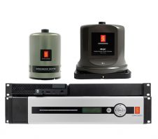
Seabed
Seabed will release the new GNSS Receiver SGR7 at the end of the second quarter of 2017. The SGR7 is a robust, high-precision receiver, with RTK that delivers centimetre level real-time positioning or go base free with centimetre and decimetre PPP solutions using Terrastar and Veripos corrections. Capable of tracking all current and upcoming GNSS constellations including GPS, GLONASS, Galileo, Beidou, QZSS and IRNSS. It is software upgradeable to track upcoming signals as they become available. Some new features are: web interface; modem; 555 channel, all-constellation, multi-frequency heading and positioning solution; advanced interference visualisation and mitigation features; double ethernet port; multiple serial and event outputs; IP67 and 16GB internal storage. Possible features: display; WiFi; triple antenna; RTK Assist; align; span; INS Enabled; Terrastar L-band; Veripos and upgradeable internal storage.
www.seabed.nl, V18.
Silicon Sensing
Two all-new inertial measurement units from Silicon Sensing Systems Limited, which are enhancing their successful range of MEMS inertial products, are to be featured at Ocean Business 2017 (Find Silicon Sensing on Stand V30). DMU11, like its predecessor DMU10, combines MEMS angular rate and linear acceleration sensors to create a precision, low-cost, six-degrees-of-freedom (6-DOF) IMU for a complete motion sensing solution. DMU11 features a redesigned layout for applications where space is at a premium and is calibrated over the full rated temperature range. Also the first of a family of High Performance IMUs, DMU30 creates a ground-breaking, non-ITAR, MEMS IMU alternative to more costly ‘FOG-grade’ equivalent for use in exacting marine motion sensing applications.
Sonardyne International Ltd
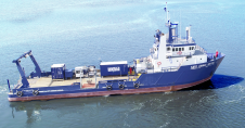
Visit Sonardyne on Stand E1 to learn how you can now access your subsea data when you want, where you want, by equipping your marine robotic platforms, vehicles and vessels with their acoustic positioning, optical communications, inertial navigation and sonar imaging technologies. Sonardyne’s trials vessel Echo Explorer will once again be at the show, giving visitors the opportunity to see some of the products on display inside, in action out on the water. These will include a Mini-Ranger 2 tracking system, Nano transponder, Syrinx DVL and SPRINT INS. The company will also be hosting three classroom sessions, one of which will be presenting recent advances in underwater dynamic mobile mapping.
Teledyne CARIS
Introducing the HIPS ‘Essential’ application, tailored for use by Ports and Waterways and small survey companies. HIPS ‘Essential’ will meet your standard multibeam processing workflow requirements with quality assured and a cost-effective price. As part of the HIPS and SIPS family, HIPS ‘Essential’ maintains the robust nature you have come to expect from CARIS products and is easily expanded to meet your growing needs.
Teledyne Marine
Make Teledyne Marine your first stop on stands T5 and U12 where you'll discover the largest breadth of technology in the marine industry. Whether you’re looking for interconnect, instruments, vehicles, or imaging solutions, Teledyne Marine can assist you with stand-alone products or fully integrated custom systems – all from one supplier. Our OneTeam of professionals will be ready and waiting to help you solve your biggest marine challenges. Teledyne Marine will be previewing several new and exciting technologies at this event. Be sure to stop by our booths for full details. Teledyne Marine will also be hosting +20 classroom training sessions, dockside, test tank and on-water demos throughout this 3-day event. Contact us if you’d like to pre-register for any of these events.
www.teledynemarine.com, T5,U12
Valeport
Valeport is using Ocean Business17 as the launch venue for a new sensor especially designed for the dredging community. Recognised as world leaders in sound velocity technology, Valeport’s latest addition combines a new turbidity sensor with the SWiFT SVP (CTD) technology to create dredgeMATE - a very useful new profiler aimed at the dredging market. Valeport will also introduce Connect, a software platform for mobile and PC devices. Product manager, Jim Gardner, will host a training session on Tuesday 4 April, 3.30pm at Ocean Business to present the software platform which is designed for Bluetooth connectivity to interface, configure and download data from both legacy and new products.
www.valeport.com, M1
Veripos
Veripos leverages the Global Navigation Satellite Network (GNSS) and our own fully redundant proprietary corrections network to deliver highly accurate, reliable GNSS augmentation services for survey, dynamic positioning and other marine applications. Focused on reliability, innovation and around the clock customer support, our services include our Apex5 multi-constellation service which provides corrections for GPS, GLONASS, BeiDou, Galileo and QZSS constellations as well as our Quantum quality control software. Veripos corrections are delivered via redundant delivery mechanisms on 7 satellite beams ensuring customers global availability. With regional offices in Houston, Singapore, Mexico, Brazil, Australia and China and support offices in South Africa, Egypt, Middle East and India, Veripos offers truly global installation support and calibration services for all its products and services.
www.veripos.com, C6
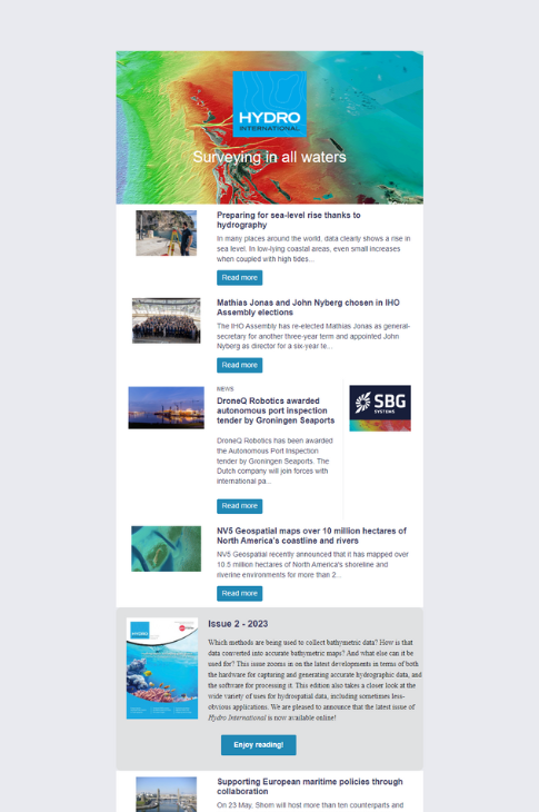
Value staying current with hydrography?
Stay on the map with our expertly curated newsletters.
We provide educational insights, industry updates, and inspiring stories from the world of hydrography to help you learn, grow, and navigate your field with confidence. Don't miss out - subscribe today and ensure you're always informed, educated, and inspired by the latest in hydrographic technology and research.
Choose your newsletter(s)