The evolution of Dutch hydrography
Given the Netherlands’ geographical location, it is unsurprising to find it has a long tradition of hydrography. The lowland, often below sea level, forms a delta where major rivers from...

Given the Netherlands’ geographical location, it is unsurprising to find it has a long tradition of hydrography. The lowland, often below sea level, forms a delta where major rivers from...
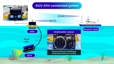
Fujitsu has presented a pioneering technology that harnesses Lidar and AI to capture high-resolution 3D data of organisms, coral reefs and man-made structures such as offshore wind turbines using autonomous...
By harnessing capabilities of advanced satellite technology and ever-evolving data analysis, satellite-based mapping (including satellite-derived bathymetry, SDB) offers an efficient, extensible and cost-effective method for mapping water properties, underwater topography...
The Mexico port authorities have enhanced their port security capabilities with the recent acquisition of nine advanced Oceanbotics SRV-8 professional underwater drones (ROVs). This strategic move aims to elevate their surveillance...
In an era of great power competition, unmanned maritime systems (UMSs) have begun to take centre stage and are now on an accelerated development path for reasons that are clear....
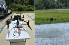
In the quest to unravel the mysteries beneath our planet’s water bodies, topobathymetric technologies emerge as a beacon of innovation. Among them, Lidar (light detection and ranging) and sonar sensors...
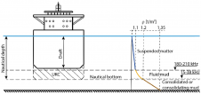
The presence of suspended sediments in water bodies presents significant challenges for the dredging industry. Existing methods to determine nautical depths are intrusive single point methods relying on in situ density or shear strength measurements1,3 or low-frequency single-beam echosounder recordings1,2. The use of single-beam echosounders is however systemically problematic as they are not practical in satisfying the CATZOC A1 coverages required for contemporary electronic navigational charting. The presence of suspended sediments in water bodies presents significant challenges for the dredging industry. Existing methods to determine nautical depths are intrusive single point methods relying on in situ...

IIT Madras has established a Centre of Excellence (CoE) dedicated to advancing indigenous maritime technology and expertise. The team of researchers leading this initiative has been actively engaged in notable...
With innovation, progress and discovery at its heart, Oceanology International 2024 (Oi24) is preparing to welcome the world’s largest gathering of ocean professionals to the most powerful and inspirational event...
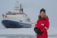
After eventful and busy months, the Arctic season of the ArcWatch-1 Polarstern expedition ended this weekend. The team of almost 100 crew and scientists measured sea ice thickness and properties,...
This site uses cookies. By continuing to use this website, you agree to our Cookies Policy. Agree