The impact of topobathymetric technologies in hydrography
How uncrewed aerial systems and sensor miniaturization are revolutionizing topobathymetric applications
In the quest to unravel the mysteries beneath our planet’s water bodies, topobathymetric technologies emerge as a beacon of innovation. Among them, Lidar (light detection and ranging) and sonar sensors mounted on uncrewed aerial systems (UASs) are pushing the boundaries of what is possible. Offering unprecedented precision in mapping underwater landscapes, these technologies are revolutionizing hydrography, environmental monitoring and coastal management. This article delves into the latest advancements in topobathymetric Lidar and sonar, highlighting their critical role in understanding and protecting our aquatic environments. From its origins to its future potential, we explore how Lidar technology illuminates the depths like never before.
Bathymetry, the study of underwater topography, plays a crucial role in various fields by mapping the seafloor to support navigation, scientific research and environmental management. It involves collecting data to create detailed charts used in navigation, to study seafloor profiles for biological oceanography, to assess coastal erosion and to monitor sea-level rise. This data is vital for safely managing natural hazards such as floods and river erosion, ensuring navigable waterways, and aiding in the design and maintenance of ports, harbours and urban planning. Topobathymetric data, which merges topographic and bathymetric information, further enhances our understanding of both terrestrial and aquatic environments.
Trending bathymetric surveying technologies
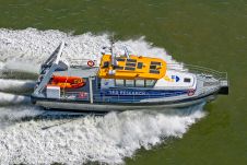
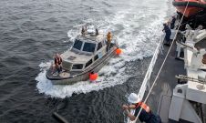
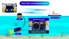
Numerous techniques have been used over the years to collect bathymetric data. These include hydrographic surveys, ship/boat-based sonar, airborne topobathymetric Lidar, satellite-derived bathymetry (SDB), advanced topographic laser altimeter systems (ATLAS) and, more recently, UAS bathymetric Lidar and UAS bathymetric echosounder/sonar. Moreover, marine vessels are equipped with sonar systems featuring both multibeam echosounder (MBES) and single-beam echosounder (SBES) configurations. Significantly, advancements in acoustic seabed mapping now involve the use of multifrequency multibeam sonars, allowing for the simultaneous collection of submerged bottom data at various frequencies within a singular survey. This technological capability significantly augments the precision and thorough characterization of underwater terrains, especially in deep water bodies. Moreover, autonomous underwater vehicles (AUVs), underwater remote-operated vehicles (ROVs) and unmanned surface vehicles (USVs) have also been utilized to collect bathymetric data. Sonar technologies excel in deep-water surveys due to their superior water penetration and detailed data collection capabilities. However, options for reliable and accessible technologies in shallow-water environments are limited. Emerging technologies such as UAS-Lidar and UAS-sonar are addressing this gap, offering promising advancements for shallow-water data collection.

Pros and cons of the technologies
Various bathymetric data collection technologies offer their own set of advantages and challenges. Manual hydrographic surveys, while accurate, are labour-intensive and prone to human error, making it difficult to cover large areas effectively. Ship- or boat-based sonar, ideal for large surveys, faces limitations in shallow waters, involves high costs and requires specialized training. Airborne topobathymetric Lidar allows for quick data collection but demands clear water for effectiveness and is constrained by accessibility and cost issues, particularly in coastal area surveys. Additionally, SDB provides wider spatial coverage and is mostly suitable for coastal water but it has less depth accuracy than MBES and SBES and is highly dependent on prediction algorithms. ATLAS’s nearshore bathymetric mapping with ICESat-2 shows nearly one Secchi depth mapping up to 38 metres, highlighting its potential in bathymetry surveys1. However, this technology requires enhancements in the geolocation capabilities of the data.
AUVs are perfectly suited for exploring challenging environments, such as deep-sea hydrothermal vents or areas beneath polar ice sheets, due to their autonomous operational capabilities. They fill the crucial gap in spatial resolution between systems that require vessels, such as multibeam echosounders and sidescan sonars, and those mounted on ROVs, enhancing overall data collection capabilities. Capable of diving up to 6,000 metres, deep-water AUVs are pivotal in scientific exploration, providing unmatched spatial resolution and navigation precision near the ocean floor, outperforming traditional surface or towed survey equipment such as sidescan sonars2 and cameras. Although AUVs, or ROVs, provide real-time data collection, they are expensive and complex to operate.

Advances in UAS-green band Lidar and UAS-echosounder technologies are significantly enhancing shallow-water bathymetric surveying capabilities. When leveraging drone technologies, green-band Lidar offers an efficient and cost-effective means for mapping underwater landscapes, although its effectiveness is contingent on water clarity and depth penetration capabilities, which are still being optimized. Conversely, the UAS-echosounder, which is under development, promises to revolutionize underwater data collection with its lightweight design and superior water penetration abilities, potentially outperforming the UAS-green band Lidar.
Many countries, universities, governments and non-governmental organizations are actively involved in bathymetric research, as shown in Figure 3, which highlights countries where bathymetric research is being published the most, following a systematic literature review3.
Current state of UAS bathymetric survey technologies
The CZMIL (Coastal Zone Mapping and Imaging Lidar) is a comprehensive Lidar-imagery hardware-software suite that fulfils the technical requirements of the USACE National Coastal Mapping Program (NCMP) in the United States. Its experiments showcase the capabilities of a single aircraft system equipped with a topobathymetric Lidar sensor, digital camera and hyperspectral imager3. The results show that the system accurately measures depths of 7–8m in murky water and up to 41m in clear water. CZMIL stands out as a leading green-band airborne Lidar system in the market. However, integrating CZMIL with UAS systems faces challenges due to the platform’s weight. Despite this, there is a clear movement towards making green-band Lidar technology more compact for UAS and drone applications. Some notable examples include the Mapper4000U system, TDOT GREEN, VQ-840-G, photon-counting bathymetric Lidar, the ASTRALiTe EDGE Lidar, and YellowScan’s newly released Navigator Lidar sensor. Green-band Lidar is notable for its ability to collect topobathymetric data in a single scan, avoiding the need for separate data integration. Water quality has a big impact on UAS-green band Lidar, and water properties such as turbidity and clarity significantly impact how well this technique works. Remarkably, most UAS-topobathymetric Lidar systems have not been able to assess water depths deeper than 5–10m to date.

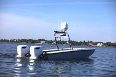
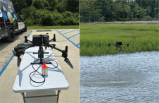
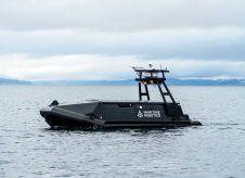
A new technology under development is the UAS-sonar/echosounding system. For example, the University of Florida has created an innovative drone-based system for underwater mapping called Bathydrone. This system features a drone connected to a small vessel equipped with a sophisticated sonar unit, capable of performing down-scan, sidescan and chirp functions. It logs GPS-referenced sonar data in real time, enhancing underwater exploration and mapping capabilities. Given that it is a lightweight surface vehicle, it has difficulty in deep-water wave environments.
SPH Engineering is developing technology that integrates an echosounder with a commercially available UAS system. The UAS-echosounder developed by SPH Engineering is recognized for its high-quality data output. However, it still requires extensive research, development and accuracy evaluation. Compared to UAS-green band Lidar, this technology boasts superior water penetration capabilities, offering a significant advantage in underwater exploration and mapping.
Pricope and Bashit3 conducted a systematic literature review of hundreds of articles and surmised that, in the realm of topobathymetric survey technologies, airborne methods lead with a 45% usage rate, while radar is the least utilized at 1%. Drones, UAVs and UASs account for 9%, highlighting the growing significance of unmanned aerial vehicles in this field. Additionally, the ‘Others’ category represents 18%, indicating a variety of innovative and hybrid approaches beyond the main technologies, showcasing the diversity in survey methods.

The future of topobathymetric mapping
The advent of UAS/drone-mounted echosounders and Lidar represents a significant leap in bathymetric data collection, offering unparalleled flexibility and efficiency. These technologies enable the deployment of compact yet powerful sensors for swift and precise mapping of underwater topographies, presenting a cost-effective alternative to conventional survey methods. Moreover, drones facilitate access to challenging or dangerous areas, enhancing data collection speed, accessibility and safety across aquatic environments. Importantly, the real-time data transmission feature of these tools underscores their value in modern bathymetric applications, highlighting the critical role of interdisciplinary collaboration and data sharing in advancing topobathymetric mapping efforts.
Conclusion
The exploration of bathymetric data’s essential role in maritime safety, infrastructure and flood protection has spotlighted recent advancements in UAS-green band Lidar and UAS-echosounder technologies. We highlight both the advantages and challenges of current bathymetric survey methods, underlining the progress and miniaturization trends of tools such as CZMIL. Researchers worldwide working in this field envision a transformative future for UAS-mounted technologies in hydrography, poised to redefine underwater mapping with unprecedented efficiency and precision. This evolution promises a new era of enhanced marine safety and swift, accurate terrain mapping, heralding significant advancements for hydrological applications and research.
References
1Parrish, C. E.; Magruder, L. A.; Neuenschwander, A. L.; Forfinski-Sarkozi, N.; Alonzo, M.; Jasinski, M. Validation of ICESat-2 ATLAS Bathymetry and Analysis of ATLAS’s Bathymetric Mapping Performance. Remote sensing. 2019, 11 (14), 1634.
2Murton, B. J.; Rouse, I. P.; Millard, N. W.; Flewellen, C. G. Multisensor, deep‐towed instrument explores ocean floor. Eos, Transactions American Geophysical Union 1992, 73 (20), 225-228.
3Pricope, N. G.; Bashit, M. S. Emerging trends in topobathymetric LiDAR technology and mapping. International Journal of Remote Sensing 2023, 44 (24), 7706-7731.
Value staying current with hydrography?
Stay on the map with our expertly curated newsletters.
We provide educational insights, industry updates, and inspiring stories from the world of hydrography to help you learn, grow, and navigate your field with confidence. Don't miss out - subscribe today and ensure you're always informed, educated, and inspired by the latest in hydrographic technology and research.
Choose your newsletter(s)