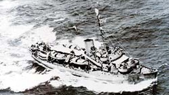
Small Boat Work – Dangerous Then, Dangerous Today
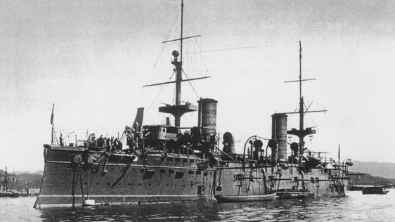
The ability to conduct inshore hydrographic surveys has always been dependent on small boats and the seamanship of those conducting the surveys. Besides the obvious use of small bo...
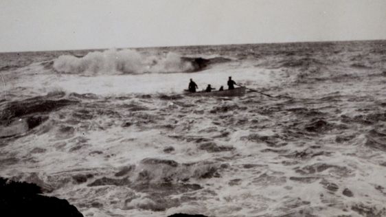
The ability to conduct inshore hydrographic surveys has always been dependent on small boats and the seamanship of those conducting the surveys. Besides the obvious use of small bo...

This month marks the 555th anniversary of the death of Prince Henry of Portugal, known as the Navigator, on 13 November 1460. Henry had set in motion a series of events that led to...
Thirty Years of Discovering the Mariana Trench On 23 March 1875, HMS Challenger sounded in 4475 fathoms at latitude 11°24N, longitude 143°16E to the southwest of the Marian...
Historically, perhaps the naval discipline most related to the work and skills of the hydrographer is naval mine warfare. Successful implementation requires knowledge of the config...

The Indonesian archipelago is one of the world’s most beautiful archipelagos. Home to over 17,000 islands, mountains rising to over 5,000 metres, including over 70 historical...
Follow Hydro International on Facebook, LinkedIn, Twitter or sign up for the newsletter! Don't miss the latest developments: join Hydro International!
 |  |  |  |
| 14.540 SUBSCRIBERS | 7.245 MEMBERS | 5.205 LIKES | 4.632 |

Once upon a time there was no satnav, multibeam sonar or a computer to handle a survey system. Hydrographic surveying was done ‘by hand’ with instruments long forgotten...
"Land in sight", a cry soon to be followed by "Clew up the main", to reduce speed. It is 1606 as the Dutch ship Duyfken makes first recorded landfall in Austral...
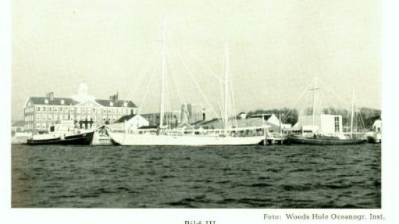
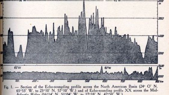
Following Maurice Ewing’s first cruise to the Mid-Atlantic Ridge, two more were made by the end of the 1940s. The first of these was led by Ewing while the second was led by...
Despite bitter experiences in earlier conflicts, it was not until the French Revolutionary War was in full swing that Britain established a very small ‘Hydrographical Office’ to or...
In 1520, the Portuguese explorer Magellan discovered the long and tortuous strait connecting the Atlantic and Pacific Oceans. The high land south of this dangerous fairway was thou...
The late Professor Taylor, a former Registrar General for Scotland, whilst researching the Balfour Collection of documents at the National Library of Scotland, came across a set of...
In 2004 the Royal Netherlands Navy for the third time in 75 years named one of two newly constructed hydrographic survey ships <i>Snellius</i>. Willebrord Snel van Roye...
From 21 to 24 June 2013, a NOAA team from the Office of Coast Survey (OCS) and the Office of National Marine Sanctuaries (ONMS) conducted a joint mission to explore a shipwreck off...
Part 1 dealt with HMS Owen and the redoubtable nineteenth century hydrographer and explorer after whom she had been named. That Summer of 1953 the second of the two British surveyi...

The French navy has located La Minerve, one of its submarines that disappeared more than 50 years ago. Onboard were 52 crewmembers. The submarine was discovered on the seabed...
Prior to the development of modern navigation methods and modern charts, the mariner was left to his own devices both in approaching unknown and known coasts. Although Lucas Janszo...
Two famous scientists, Charles Darwin (1809-82) and John Murray (1841-1914) differed greatly as to how tropical atolls had assumed their unique structure: a shallow lagoon surround...
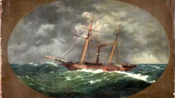
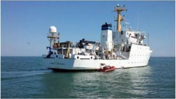
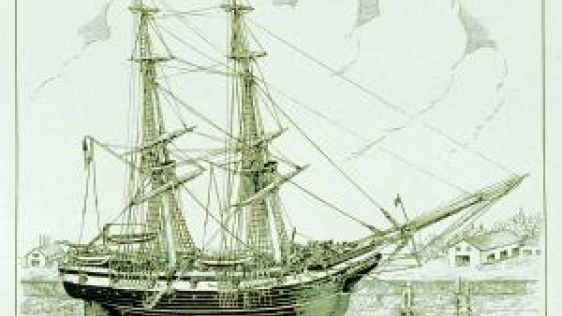
On 20 June 1860, the iron-hulled United States Coast Survey Steamer Robert J. Walker was proceeding to New York City, its home port. The ship, under the command of Navy Lieutenant...
Prior to the mid-19th century, the floor of the world ocean was virtually a clean slate. Nothing was known of the bottom of the deep sea with the exception of a few sporadic soundi...

The names Augustus Petermann, Victor Hensen, Carl Chun, Fritz Spiess, Alfred Merz, and Gunter Dietrich are hardly household names. Even today their names are little known in the ge...
With this publication, the author – George Stephen Ritchie, founder and first editor of this column – marked himself as a noted maritime historian and, particularly, a...

The high cost of exploration in subarctic, often uncharted, waters was demonstrated in an unorthodox but convincing way by the 1974 grounding and sinking of the MV Minna off R...
Research vessels are by no means ad hoc inventions. The following story describes the three-year circumnavigation by the Italian corvette Vettor Pisani that successfully combined m...
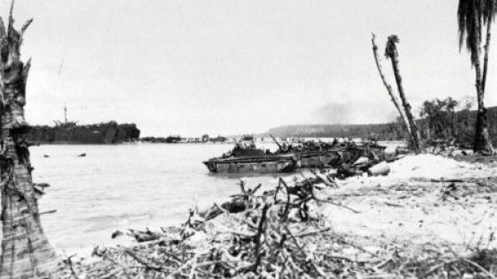
In the Second World War, the Pacific was poorly charted, and the Navy would require the services of a cadre of hydrographers to rapidly survey areas of tactical and strategic inter...
1939 marked the beginning of a concerted programme to chart the Bering Sea area. The surveys in this area that were conducted prior to United States entry into the Second World War...
Olaus Magnus, a Swedish Catholic priest, had for some years been employed collecting funds for the Church in the far north. During his extensive travels he made copious notes and s...
James Cook in the Endeavour circumnavigated New Zealand in 1769-1770 and the coastline was surveyed. Thus the coastline appeared complete on the world map. The coast is rugged and...
The Florida Reef became a menace to shipping in the 1500s when the Spanish discovered that the safest way home for their New World gold and silver was north through the Florida Str...
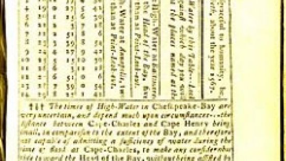
Although tidal ranges in America are, in general, less than in Europe, they have still had an impact on history. Many harbours were only accessible with high tide, introducing a l...

Radio-acoustic-ranging (RAR) navigation, developed within the US Coast and Geodetic Survey (C&GS), was the very first survey-quality navigation system that did not need to see...
On 21 March 1942, General Douglas MacArthur had just escaped from conquering Japanese forces that had overrun the Philippine Islands. In a speech that day he vowed “…...

During the California Gold Rush, many people from around the world left everything behind - including their jobs - to seek their fortune in California. A copy of one of the more in...
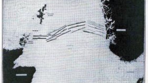
The great classical continent-spanning geodetic networks of the Nineteenth and Twentieth centuries had two major obstacles to overcome – distance and the curvature of the Ear...
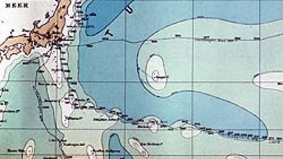
North Atlantic hurricane season is now upon us. Until well into the twentieth century there was little understanding of the nature of hurricanes and no adequate system to warn mari...

A glance at a map of the Philippine Islands shows that the Sulu Sea is nearly an enclosed body of water: the Sulu Archipelago on the southeast; Palawan to the northwest; the main b...
This site uses cookies. By continuing to use this website, you agree to our Cookies Policy. Agree